Errol Farr, Chief Executive Officer states: "We are very pleased to engage Caracle Creek to complete our first 43-101 Technical Report on Loveland. A requirement of the Canadian Securities Exchange, the Report will provide the foundation for future exploration activities on the property and continue the execution of the Company's Buy Timmins strategy".
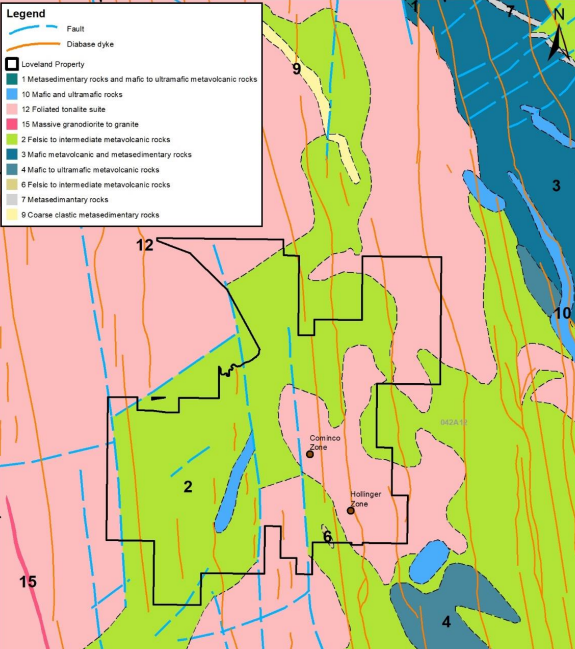
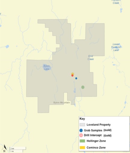
The Loveland Property is located in Byers, Loveland, Thorburn, and Moberly townships, in the Porcupine Mining Division. The Property lies within the southwest portion of the prolific Abitibi Greenstone Belt of the Archean Superior Province. The local geology consists of intercalated mafic to intermediate volcanic flows. These flows are locally intruded by feldspar porphyries and gabbro. The gabbroic rocks have similarities to the Kamiskotia gabbroic complex.
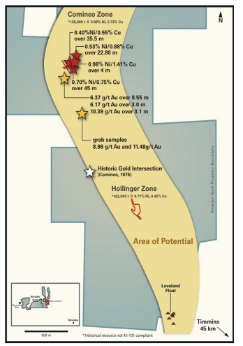
Gold mineralization was intersected in holes drilled by Amador Gold Corp. to a depth of 300 m below the historical Cominco Zone deposit in 2007-2009(4). Gold-bearing arsenopyrite and pyrite mineralization was encountered in sections of silicified granodiorite. Amador's significant historical drill hole (LL08-13) intersected a mineralized interval that assayed 6.37 g/t Au over 8.55 m (383.25 m to 391.8 m down-hole). Additional intervals from the hole included 6.17 g/t over 3.0 m from 403.0 m to 406.0 m and 10.39 g/t over 3.1 m from 410.30 m to 413.4 m.(4) The reported lengths of gold intersections are core lengths and not true lengths which are currently unknown.
Anomalous gold values ranging from 100 ppb to 3800 ppb were recorded from several other drill holes (including AMDG07-01, LL08-04, LL08-09, LL09-13W, LL08-14, LL08-21, LL08-22, and LL08-23) over a strike more than 500 m within the granodiorite. The anomalous gold values occur over various widths from less than a metre to several metres of core. True widths are unknown. Prospecting in 2008 led to the discovery of a surface gold showing about 400 m southeast of the historical Cominco Zone deposit. The showing returned grab samples containing 8.98 g/t Au and 11.48 g/t Au collected from granodiorite containing quartz-stringers mineralized with disseminated sulphides(5)(6).
The gold-bearing sulphide mineralization occurs with silicification that presents as silica flooding and quartz veining. The better values, such as those from hole LL08-13, occur in intervals with blue-grey quartz veining and strong silicification with 3-10% sulphides comprising arsenopyrite, pyrite and trace amounts of sphalerite, and possibly trace galena and chalcopyrite. Silicification with trace to 2% sulphides was observed marginal to joints and local quartz stringers in all holes where anomalous gold was recorded.
The results from Amador's drilling suggest the presence of a system of gold enrichment within the granodiorite. Additional exploration will be required to determine the orientation and extent of the gold-enriched zone.
For more information on Loveland's nickel/copper potential see the Company's press release dated June 30, 2025.
.png)
The Hollinger and Cominco zone historical mineral resource estimates are unclassified and do not comply with CIM Definition Standards on Mineral Resources and Mineral Reserves as required by NI 43-101. The Hollinger zone historical mineral resource estimate was taken from a report titled "Geological Report, Rousseau Loveland Property, Loveland Township" authored by W. C. Kerr and dated February 1992, citing data provided by Hollinger Mines Limited from 1974. The Cominco zone historical mineral resource estimate was taken from a report titled "Amador Gold Corp. – Annual Report 2009" dated May 26, 2009.
Given the age of the information and the lack of underlying data, investors are cautioned not to treat the estimate as current or rely on the estimate in making an investment decision. The historical mineral estimate is being included herein to provide shareholders with background on the rationale for acquiring the asset. A qualified person has not done sufficient work to classify this historical mineral resource estimate as current mineral resources and the Company is not treating these historical mineral resource estimates as a current estimate. It is uncertain whether following evaluation and/or further exploration, the historical mineral resource estimate will ever be able to be reported in accordance with NI 43-101. The Company has no current plans to undertake the work to bring any or all of the historical resource estimates up to the CIM reporting standards.
Curtis Ferron, P.Geo. (ON), independent consultant for Loyalist, who is a "Qualified Person" as defined by NI 43-101, has reviewed and approved the technical content of the page.