December 15, 2013 by Francis Minerals Ltd
| Model | Classification | Tonnes (*1000) | Grade (Au g/t) | Grams Au (*1000) | Ounces Au |
|---|---|---|---|---|---|
| Capped | Indicated | 358 | 6.56 | 2,350 | 76,000 |
| Capped | Inferred | 184 | 5.17 | 1,000 | 31,000 |
| Uncapped | Indicated | 362 | 8.70 | 3,150 | 101,000 |
| Uncapped | Inferred | 186 | 7.17 | 1,337 | 43,000 |
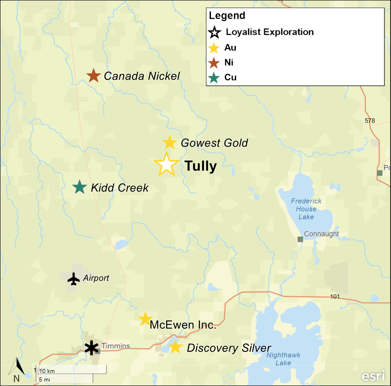
Tully is located approximately 25 kms northeast of Timmins and includes an historic indicated and inferred Mineral Resource Estimate (not published). The Project is located within the Timmins-Porcupine Gold Camp and is approximately 2 km southwest of the Bradshaw Gold Project of Gowest Gold Ltd. The Timmins-Porcupine Gold Camp, includes the Dome and Hollinger mines.
Prospective structures splay off the Porcupine-Destor Fault through the Tully area. Mineralisation at Tully occurs within a 30 m wide mafic volcanic unit with an approximate west-southwest strike and steep northerly dip. The hanging wall consists of sedimentary rocks and the footwall consists of ultramafic rocks. As currently understood, the deposit comprises an array of shallowly inclined quartz-carbonate veins or lenses stacked 'ladder-style' within the volcanic rocks and constrained by its hanging wall and footwall contacts. The higher-grade core of the deposit extends over 600 m along strike and 400 m down dip, and plunges moderately toward the east-northeast. The mineralised veins/lenses host gold primarily within irregular pyrite clusters and also commonly as free visible gold.
The Tully property occurs within a swampy area and is covered by blanket of glacial drift, averaging 30 m thickness which hid the deposit from early explorers; thus, the geology is entirely derived from drillhole and geophysical data. Exploration by a number of companies over several decades has resulted in the drilling of many holes - the historical resource estimate utilised data from an extensive database of 356 holes totalling 91,623 m, with 718 vein intercepts being interpreted and incorporated into the lens wireframes.
A qualified person has not done sufficient work to classify the historical estimate as current mineral resources or mineral reserves. Loyalist is not treating the historical estimate as current mineral resources or mineral reserves.
The Tully deposit historical Mineral Resource Estimate ("MRE") is unclassified and does not comply with CIM Definition Standards on Mineral Resources and Mineral Reserves as required by NI 43-101. The MRE was taken from a report titled "Tully Deposit Mineral Resource Estimate" authored by Francis Minerals Ltd. and dated December 15, 2014. Investors are cautioned not to treat the estimate as current or rely on the estimate in making an investment decision. The MRE is being included herein to provide shareholders with background on the rationale for acquiring the asset. A qualified person has not done sufficient work to classify this historical MRE as current mineral resources and the Company is not treating this historical MRE as a current estimate. It is uncertain whether following evaluation and/or further exploration, the historical MRE will ever be able to be reported in accordance with NI 43-101. The Company has no current plans to undertake the work to bring the MRE up to the CIM reporting standards.
Curtis Ferron, P.Geo. (ON), independent consultant for Loyalist, who is a "Qualified Person" as defined by NI 43-101, has reviewed and approved the technical content of this page.